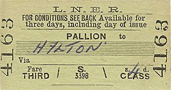
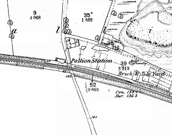
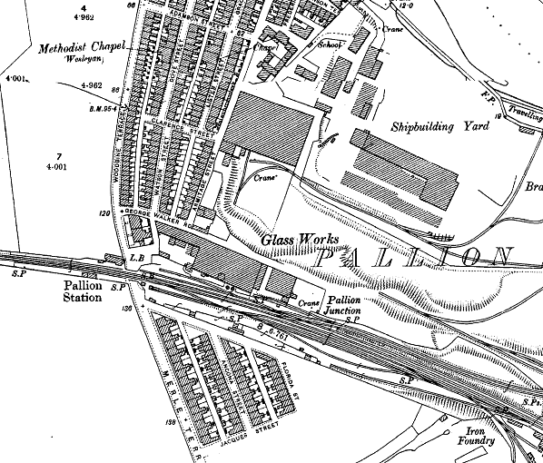
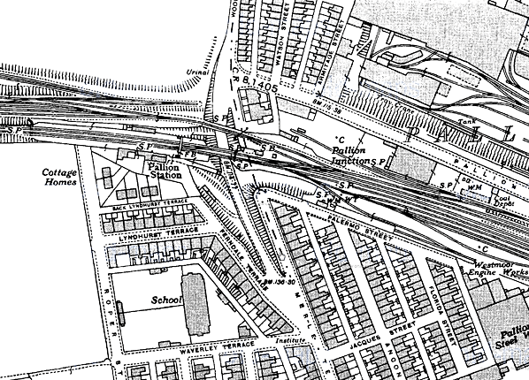
Notes: Pallion station opened with the Sunderland Fawcett Street to Penshaw line, and for some time it stood in a rural area. The original station had two short platforms, with a building on the northern (down) one, close to its eastern end; no details have been found of this structure. Situated close to the River Wear, the station increased in importance as a shipyard opened close by, accompanied by other manufactures, and residential terraces spread across adjacent land. The NER rebuilt the station with superior facilities at the end of the nineteenth century; in March 1898 authorisation was given for £9,391 to be spent on new buildings, including a station house. The principal buildings were placed on the southern (up) platform. The station house was a rather drab two-storey brick building presenting a gable to the platform at its western end, although some interest was added by the structure of the bargeboard. It was accompanied to the east by a single-storey office building which stretched along the platform. The western and eastern ends of its roof were half-hipped; the platform and exterior elevations were broken by a cross gable, with bargeboards to match those on the station house. On the down platform was a brick-built waiting room and toilet block, with a glazed timber portion, accompanied by a storage shed to its west. A standard iron footbridge was added to connect the platforms at the eastern end of the station.
By the end of the nineteenth century a full range of goods facilities was located east of Pallion station, with various sidings and a 3-ton crane. In 1913 passenger bookings amounted to 32,661 at Pallion, though serving an industrial area it is likely that this figure falls well short of the number of passengers who used the station as many employees at these factories will have booked their tickets at their home station.
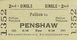
 In 1923 Pallion station came under the management of the London & North Eastern Railway and, at Nationalisation, it became part of British Railways North Eastern Region. BR showed little inclination to modernise the station, which retained gas lighting and LNER signage, limited to running-in nameboards. Train services were adequate to serve commuters travelling to and from Sunderland, with an infrequent service during the day. In 1951 Pallion issued 15,641 tickets, a substantial decline from the 1913 figure. Whilst the neighbouring station at Millfield closed in 1955 Pallion survived, but was downgraded to the curious status of a ‘staffed halt’ on 14 August 1961; the 18 June 1962 timetable indicated that it had become unstaffed. A survey in summer 1962 showed that Pallion was used by many more passengers on weekdays than on Saturdays, reflecting its industrial setting. Far more passengers used the station for journeys to and from the Durham direction than to and from Sunderland, presumably preferring buses for the short distance to the nearby town centre. In 1923 Pallion station came under the management of the London & North Eastern Railway and, at Nationalisation, it became part of British Railways North Eastern Region. BR showed little inclination to modernise the station, which retained gas lighting and LNER signage, limited to running-in nameboards. Train services were adequate to serve commuters travelling to and from Sunderland, with an infrequent service during the day. In 1951 Pallion issued 15,641 tickets, a substantial decline from the 1913 figure. Whilst the neighbouring station at Millfield closed in 1955 Pallion survived, but was downgraded to the curious status of a ‘staffed halt’ on 14 August 1961; the 18 June 1962 timetable indicated that it had become unstaffed. A survey in summer 1962 showed that Pallion was used by many more passengers on weekdays than on Saturdays, reflecting its industrial setting. Far more passengers used the station for journeys to and from the Durham direction than to and from Sunderland, presumably preferring buses for the short distance to the nearby town centre.
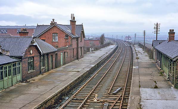
The Reshaping of British Railways (‘Beeching’) report recommended the withdrawal of the Sunderland – Durham – Bishop Auckland passenger train service, and closure came on 4 May 1964. Goods-handling ceased at Pallion on 5 July 1965, but the line through the station remained in freight use until 1976. In 1984 the rails were still in use from Pallion eastwards to Hendon (Sunderland) but in that year all freight movements ceased and the tracks were eventually removed. Although the up platform building and footbridge were demolished c1976 the house and station building remained in place for some time longer, the latter used by a construction firm. The house was derelict by 1982, and by 1991 the rails had gone and the buildings and platforms had been demolished.
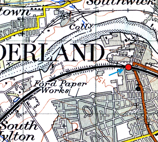
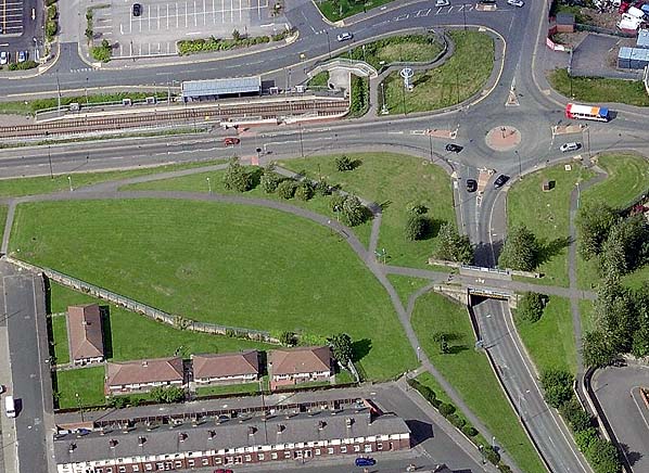
Pallion returned to the railway map on 31 March 2002 when the eastern end of the Durham – Sunderland line was reopened as part of the Tyne & Wear Metro. The section through the new Pallion station is on an alignment a short distance north of the former route.
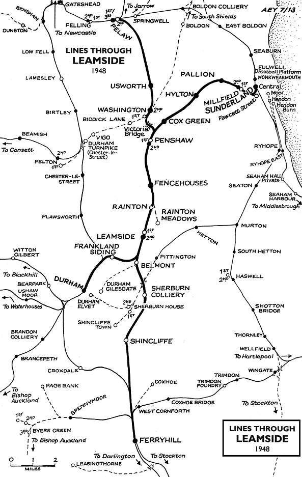
BRIEF HISTORY OF THE SUNDERLAND TO DURHAM (AND BISHOP AUCKLAND) VIA LEAMSIDE LINEDespite its name the Durham & Sunderland Railway (D&S) – not via Leamside – never did reach Durham City. Its route from South Dock, Sunderland, extended through Murton to Haswell (where the Hartlepool Dock & Railway Company already had a terminus) which opened in 1836, with a branch from Murton through Hetton, Pittington and Sherburn House to Shincliffe, two miles south-east of the Durham City centre, which opened in 1839. The North Eastern Railway eventually diverted the line from Shincliffe to terminate in Durham at Elvet station in 1893.

In an Act of 27 July 1846 the Newcastle & Darlington Junction Railway (see ‘Old Main Line’ history) was authorised to build a line from Pensher (later known as Penshaw) to join the D&S Railway at Sunderland. The line was known as the Painshaw Branch (another variation on the spelling of Penshaw). From Sunderland as far as Penshaw the line followed the River Wear valley but its route was generally some distance from the river to avoid a meander near Hylton and to serve the communities which were growing south of the river. The line opened on 20 February 1852 for goods traffic and 1 June 1853 for passengers. The terminus in Sunderland was Fawcett Street station, which opened on the same day on the southern edge of the developing commercial centre of the town.
The Bishop Auckland branch from Leamside via Durham opened to passengers on 1 April 1857. Beyond Leamside, at Auckland Junction (later known as Leamside Junction) it swung westwards from the route to Ferryhill, crossed the River Wear on a viaduct, then sharply south-west to reach Durham City. The curious dog-leg in the route enabled the line to follow the intended course of the moribund YN&B project of 1848: see details in the section below on the ‘new’ main line. Durham City’s centre is densely built up on the narrow, steep-sided peninsula within a meander of the River Wear, dominated by the cathedral and castle; the railway did not enter this historically important area, but passed by to the north-west, where a substantial viaduct was necessary and the city’s station was found.
 The Leamside – Bishop Auckland branch now provided an alternative route between Durham and Sunderland, far more convenient than via the Durham & Sunderland’s Shincliffe (for Durham) terminus – which was abandoned in 1893 when the D&S was re-routed to a terminus at Durham Elvet. On the day the Bishop Auckland branch was opened the branch from Belmont Junction to Durham Gilesgate closed to passengers: this had been opened by the N&DJ on 15 April 1844, providing the first station in Durham City. The Leamside – Bishop Auckland branch now provided an alternative route between Durham and Sunderland, far more convenient than via the Durham & Sunderland’s Shincliffe (for Durham) terminus – which was abandoned in 1893 when the D&S was re-routed to a terminus at Durham Elvet. On the day the Bishop Auckland branch was opened the branch from Belmont Junction to Durham Gilesgate closed to passengers: this had been opened by the N&DJ on 15 April 1844, providing the first station in Durham City.
From 1857 Leamside station enjoyed some importance as the de facto junction where trains to and from Sunderland and Durham connected with the services on London Kings Cross – Newcastle – Edinburgh main line. Fencehouses or Penshaw could equally have been awarded this status, but Leamside station, in its remote rural surroundings, was rebuilt with an island platform and bays at each end to accommodate the connecting services and allow convenient interchange by passengers. Its importance was short-lived and was suddenly removed when the new main line route between Ferryhill and Newcastle via Durham opened in 1872. Leamside station was now an extravagance, with little local population to serve; conversely the splendid Durham viaduct, originally serving only the Leamside – Bishop Auckland branch, was now a prominent feature of the main line providing a vantage point from which millions of passengers would be able to admire Durham and its cathedral.
In Sunderland the inconvenient gap between Monkwearmouth, the terminus of trains from Newcastle and South Shields on the north bank of the River Wear, and the lines from the south was closed in 1879 when in the ‘Monkwearmouth Junction’ project a bridge over the river and a tunnel under the town centre were constructed together with a new station known either as Sunderland (or Sunderland Central). From August 1879 Fawcett Street station closed and trains on the Durham line ran into the new station. The Central station also replaced the Hendon terminus, formerly used by trains to Seaham and West Hartlepool.
As with most lines in northern County Durham the Sunderland – Durham route carried large quantities of goods and mineral traffic, notably coal. Several collieries were directly linked to the line, and there were branches into shipyards and Deptford staiths on the Wear as well as to the Hudson, Henson and South docks on the coast.
 Expecting that coal exports from Sunderland’s South Dock would increase, the North Eastern Railway and local authorities jointly funded the construction of the Queen Alexandra Bridge, to carry both rail and road traffic in the manner of High Level Bridge between Gateshead and Newcastle. The NER paid £325,000 (including railway approaches) while Sunderland Corporation contributed £146,000 and Southwick Council a further £11,000. The new bridge and associated lines would enable coal from the ex-Stanhope & Tyne line to reach South Dock, eliminating reversals at Washington and Penshaw, using instead a mineral line from Southwick Junction (between Washington and Boldon) over the new Queen Alexandra Bridge, then the Sunderland – Durham line from Diamond Hall Junction (just west of Millfield station). The bridge opened in 1909, but from the NER perspective it was a financial disaster since it apparently carried one coal train per day until the early 1920s when regular traffic ceased. Expecting that coal exports from Sunderland’s South Dock would increase, the North Eastern Railway and local authorities jointly funded the construction of the Queen Alexandra Bridge, to carry both rail and road traffic in the manner of High Level Bridge between Gateshead and Newcastle. The NER paid £325,000 (including railway approaches) while Sunderland Corporation contributed £146,000 and Southwick Council a further £11,000. The new bridge and associated lines would enable coal from the ex-Stanhope & Tyne line to reach South Dock, eliminating reversals at Washington and Penshaw, using instead a mineral line from Southwick Junction (between Washington and Boldon) over the new Queen Alexandra Bridge, then the Sunderland – Durham line from Diamond Hall Junction (just west of Millfield station). The bridge opened in 1909, but from the NER perspective it was a financial disaster since it apparently carried one coal train per day until the early 1920s when regular traffic ceased.
Passenger services on the Sunderland – Durham line remained frequent. However from the 1920s motor buses began to provide a more intensive service and linked the numerous mining villages and towns in north-east Durham. The ‘Old Main Line’ south of Leamside lost its passenger services in 1941. On the Sunderland – Durham route, apart from the very early loss of Frankland station, between Leamside and Durham, in 1877, casualties began with Leamside in 1953, followed by Millfield in inner Sunderland in 1955. Diesel multiple units replaced steam haulage on the route during 1957.
 Further economies were exercised when Pallion and Penshaw were downgraded to ‘staffed halts’ and Cox Green became an ‘unstaffed halt’ on 14 August 1961. Passenger traffic censuses in summer 1962 and winter 1962-3 showed a respectable level of use on Monday-to-Friday of Hylton and Pallion stations, but limited traffic at the other stations, notably Cox Green. The Reshaping of British Railways (‘Beeching’) report of March 1963 recommended the withdrawal of passenger services between Sunderland, Durham and Bishop Auckland - as well as the services between Newcastle and Washington - and the official proposal of closure was published on 19 July 1963. Not a single objection was lodged to the Washington closure, which took place on 9 September 1963. BR must have been unprepared for the lack of resistance to this closure as a timetable for Usworth and Washington stations appeared in the winter 1963-4 North Eastern Region book. On 28 February 1964, having considered objections to the Sunderland – Durham – Bishop Auckland proposals, Ernest Marples, Minister of Transport, consented to the closure, and services were officially withdrawn on 4 May 1964. Further economies were exercised when Pallion and Penshaw were downgraded to ‘staffed halts’ and Cox Green became an ‘unstaffed halt’ on 14 August 1961. Passenger traffic censuses in summer 1962 and winter 1962-3 showed a respectable level of use on Monday-to-Friday of Hylton and Pallion stations, but limited traffic at the other stations, notably Cox Green. The Reshaping of British Railways (‘Beeching’) report of March 1963 recommended the withdrawal of passenger services between Sunderland, Durham and Bishop Auckland - as well as the services between Newcastle and Washington - and the official proposal of closure was published on 19 July 1963. Not a single objection was lodged to the Washington closure, which took place on 9 September 1963. BR must have been unprepared for the lack of resistance to this closure as a timetable for Usworth and Washington stations appeared in the winter 1963-4 North Eastern Region book. On 28 February 1964, having considered objections to the Sunderland – Durham – Bishop Auckland proposals, Ernest Marples, Minister of Transport, consented to the closure, and services were officially withdrawn on 4 May 1964.
The author was blissfully unaware of this development, and alighted from a Newcastle train at Durham on 15 May to catch the Sunderland train, only to be informed that the last one had gone! He decided to travel on to Darlington and Middleton-in-Teesdale instead – which was still open.
 Goods services ceased between Leamside (Auckland Junction) and Durham (Newton Hall Junction) and at Finchale siding (Frankland) on 22 October 1964. The tracks into the former Fawcett Street terminus in Sunderland, which had continued as a goods facility reached from the Durham line, were severed on 3 October 1965. Goods services were retained between Penshaw and Sunderland until 21 August 1967 when they were discontinued west of Hylton Quarry sidings. In 1971 the line from Pallion to Ford paper works at Hylton was singled and ceased to be signalled when the factory closed, but Dolomite from Hylton Quarry continued to be carried until 1976 when the line was cut back to Pallion; it was officially taken out of use on 20 November 1976. The remainder of the line to Hendon, including Deptford Johnson Siding closed to goods on 27 November 1984. The section of the ‘Old Main Line’ which the Sunderland – Durham services shared between Penshaw Junction and Auckland Junction continued in goods use for some years more, but was ‘mothballed’ in 1991 and closed in 2012. Goods services ceased between Leamside (Auckland Junction) and Durham (Newton Hall Junction) and at Finchale siding (Frankland) on 22 October 1964. The tracks into the former Fawcett Street terminus in Sunderland, which had continued as a goods facility reached from the Durham line, were severed on 3 October 1965. Goods services were retained between Penshaw and Sunderland until 21 August 1967 when they were discontinued west of Hylton Quarry sidings. In 1971 the line from Pallion to Ford paper works at Hylton was singled and ceased to be signalled when the factory closed, but Dolomite from Hylton Quarry continued to be carried until 1976 when the line was cut back to Pallion; it was officially taken out of use on 20 November 1976. The remainder of the line to Hendon, including Deptford Johnson Siding closed to goods on 27 November 1984. The section of the ‘Old Main Line’ which the Sunderland – Durham services shared between Penshaw Junction and Auckland Junction continued in goods use for some years more, but was ‘mothballed’ in 1991 and closed in 2012.
Sources and bibliography:
- Biddle, Gordon Victorian stations (David & Charles 1973)
- Biddle, Gordon Britain’s historic railway buildings (Oxford University Press 2003)
- Bragg, S and Scarlett, E North Eastern lines and stations (NERA 1999)
- Clinker, C R Register of closed passenger stations and goods depots
(Avon Anglia 1978)
- Cook, R A and Hoole, K North Eastern Railway historical maps
(RCHS 2nd edition 1991)
- Fawcett, Bill A history of North Eastern Railway architecture (Three volumes)
(NERA 2001-05)
- Fawcett, Bill George Townsend Andrews of York (NERA 2011)
- Guy, Andy Steam and speed: railways of Tyne and Wear from the earliest days
(Tyne Bridge Publishing 2003)
- Hoole, Ken A regional history of the railways of Great Britain: vol 4 The North East
(David & Charles 2nd edition 1974)
- Hoole, Ken Railway stations of the North East (David & Charles 1985)
- Hurst, Geoffrey Register of closed railways 1948-1991(Milepost Publications 1992)
- Quick, Michael Railway passenger stations in Great Britain: a chronology
(RCHS 2009)
- Sinclair, Neil T Railways of Sunderland (Tyne & Wear County Council Museums 1985)
- Teasdale, John G (Ed) A history of British Railways’ North Eastern Region (NERA 2009)
- Young, Alan Lost stations of Northumberland & Durham (Silver Link 2011)
- Hansard Various (HMSO)
- North Eastern Express North Eastern Railway Society (various)
- Darsley, Roger R Darlington - Leamside - Newcastle (Middleton Press 2008)
Tickets from Michael Stewart (except 1673 JC Dean) Bradshaw from Chris Totty. Route maps drawn by Alan Young.
To see other stations on the Old Main Line click on the station name: Felling 2nd, Felling 3rd  , Felling 1st, Pelaw 1st, Pelaw 3rd, Pelaw 4th , Pelaw 2nd, Usworth, Washington 2nd, Washington 1st, Penshaw 1st, Penshaw 2nd, Fencehouses, Rainton, Rainton Meadows (on branch), Leamside 1st, Leamside 2nd, Belmont Junction, Durham Gilesgate (on branch), Sherburn Colliery, Shincliffe & Ferryhill , Felling 1st, Pelaw 1st, Pelaw 3rd, Pelaw 4th , Pelaw 2nd, Usworth, Washington 2nd, Washington 1st, Penshaw 1st, Penshaw 2nd, Fencehouses, Rainton, Rainton Meadows (on branch), Leamside 1st, Leamside 2nd, Belmont Junction, Durham Gilesgate (on branch), Sherburn Colliery, Shincliffe & Ferryhill
See also Coxhoe (branch from Ferryhill)
See also: Springwell, Brockley Whins (1st site), Brockley Whins (2nd site)
& Boldon (route prior to 1850)
See also Sunderland and Durham (via Leamside):
Durham (still open), Frankland, Cox Green, South Hylton , Hylton, Pallion 2nd , Millfield 2nd, Millfield 1st, Millfield 3rd , Sunderland Fawcett Street (on branch) & Sunderland Central (Still open)
Station still open as part of the Tyne & Wear metro |

old12.jpg)
old13.jpg)
old2.jpg)
old10.jpg)
old11.jpg)
old4.jpg)
old14.jpg)
old6.jpg)
14.jpg)
18.jpg)
4.jpg)

 Home Page