
Station Name: YARMOUTH SOUTH TOWN[Source:
Darren Kitson]
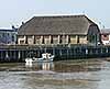
Yarmouth South Town Gallery 8: 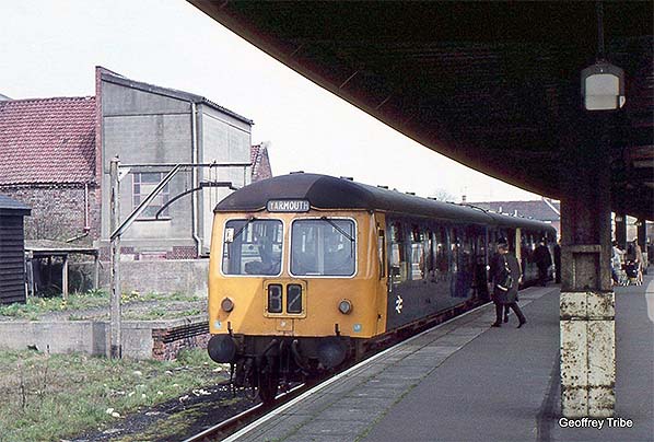 A 2-car Cravens DMU waits at South Town's sole remaining platform, No.4, on the final day of services, Saturday 2 May 1970 while the disused dock and loading gauge look on. This particular DMU had been photographed several times at various locations along the line on the final day but by the time of the final departure, the 21:10 to Lowestoft Central, it had been joined by two more Cravens units to form a 6-car set. Beneath the canopy a couple of the surviving LNER-style lamp shades can be seen. Also on the platform is at least one pram, with the door of the DMU's van open and ready to receive it. Today, prams are a very rare sight and with small children now wheeled around in much more convenient folding 'buggies' it is perhaps not easy to appreciate just how inconvenient the loss of a train service could be half a century ago. The passenger trains of old had large brake compartments into which passengers could place prams, bicycles, wheelchairs, large items of luggage and so on without any hassle or, usually, a need to pre-arrange. The guard would open the doors and willingly give other assistance if needed. It is all a far cry from most trains of today on which passengers, never mind luggage and other items, are viewed almost as a necessary nuisance. On the lower front of the DMU, the blue squares are the multiple unit coupling code while the 'LW' stencilled on it indicates 'Lightweight', a reference to the units' construction involving an amount of aluminium alloy. The car facing the camera is a Driving Trailer Composite Lavatory (DTCL), the rear car being a Driving Motor Brake Second (DMBS).
Photo by Geoffrey Tribe 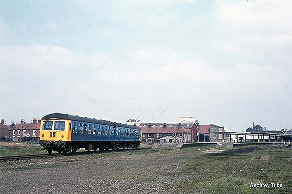
In this view, again taken on 2 May 1970, the destination blind has been changed to show Lowestoft and the Cravens DMU has rasped away from Platform 4 at the start of its journey. After a minute or so of passing through the dereliction outside South Town, the unit will reach the former Yarmouth South Town Junction and swing away south-eastwards towards Gorleston and more dereliction will be witnessed by passengers all the way to Coke Ovens Junction (Lowestoft). It was a sad end to a once thriving line serving coastal holiday destinations and camping sites. The remainder of the track at South Town had been lifted during 1968 so, had the date not been known, this scene could have dated from anytime in the 1968 - 70 period. However, what are almost certainly two railway enthusiasts can be seen with their heads out of the door droplights, thus offering a clue that this was no ordinary day. The two running-in boards, which were of LNER origin, are still present, one on each island platform. Whilst the boards were by this time something of a memory of busier times, if not looking rather incongruous, they were still required as South Town was still an operational station,
Photo by Geoffrey Tribe
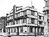
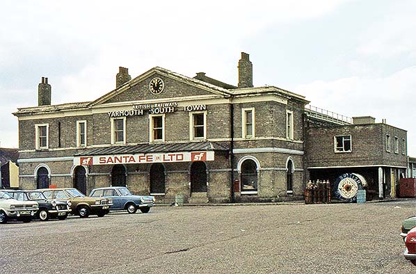 This was the scene sometime during 1975 when Sante Fe had a presence; a North Sea exploration company. They rented the station for warehousing and distribution to the oilfields in the Southern North Sea. In comparing this view to another view from 1975 it would appear the clock was still working, but then providing its power supply was not disconnected one would expect it to be. This view offers a slightly closer look at the doorway altered to form what is thought to have been a loading bay. Tucked in the corner, on the front of what had been the stationmaster's office, the letterbox is still present. For many years a pillar box had stood on Southtown Road in front of the station but whether the letterbox seen here replaced it is not known. It would seem unlikely the GPO would maintain two such facilities within yards of each other. The awning seen here replaced an earlier wooden structure of typical railway appearance and which had covered the entire frontage and extended around the corner on the right. Of the cars clearly visible we have, left to right, a Vauxhall Viva HC, Triumph Herald, Vauxhall Victor FE and a Ford Cortina Mark I.
Photo by Crewcastrian from his Flickr photostream
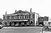
 Looking along Platform 2 at the gardener’s nightmare that was South Town station in 1976. Platform 3/4 has been cut back to the end of its canopy; this and the fencing on the left imply that BR had already started selling off parcels of land. At right foreground two stanchions which once supported a running-in board remain. The list of the nearest stanchion was present when the station was still open. In the right background Messrs Jewson have taken over the site of the coal yard and cattle dock as well as erecting a Dutch barn type structure, centre right background, through which can be seen The Yare hotel. A close up of The Yare in its former Odeon-style splendour can be seen elsewhere in these pages. Through the gap where the tracks to the goods yard ran can just be made out the end of what is suspected of being the former GER goods shed. The goods yard had closed prior to South Town's goods facilities being withdrawn entirely and the finding of new uses for the goods yard had begun almost immediately; for example part of it near the goods shed came to be used by a business selling sheds and greenhouses.
Photo by David Burrows from his Flickr photostream 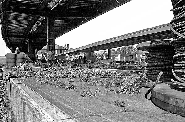
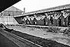
The accoutrements, or junk depending upon your point of view, of the North Sea industry had taken over Platforms 3 and 4 in 1976 while the trackbed of Platform 1, right, is used for car parking. Platform 4 is at the extreme left and it was from here the final train, a 6-car Cravens DMU, rasped away to Lowestoft at 21:10 on 2 May 1970. In the right background is the rear of what is now Plevna Terrace. In telling the story of the Prince of Wales' visit to Yarmouth in 1882, one source claims people climbed onto the rooftops of the houses to witness the arrival. If true the people must have been quite daring to balance upon those pitched roofs. However, given that in 1882 the station's trainshed would have blocked the view and the station building, by that time extended, would have blocked the view of the forecourt such stories have to be taken with the proverbial pinch of salt. One wonders if the lady on Platform 3
was Mrs Photographer. Photo by David Burrows from his Flickr photostream 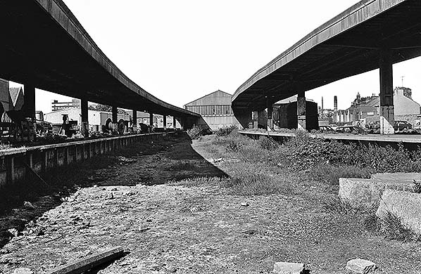
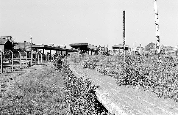
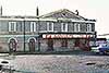
The desolation of South Town viewed here in 1976 from a point where the centre road between Platforms 2 and 3 once ran. After some time out of use, virtually all the track excepting that serving Platform 4 and the goods yard roads had been lifted during the spring of 1968. On Platform 1, right, sits a former BR Door-to-Door container; one of several containers and van bodies scattered around the site at this time. To the left of the now closed-off station concourse is the 1952 refreshments and waiting room while to its left and facing onto Bridge Road is the Railway Hotel. The almost adjacent Two Bears is out of view to the left.
Photo by David Burrows from his Flickr photostream 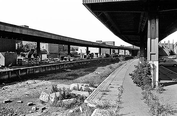
The accoutrements, or junk depending upon your point of view, of the North Sea industry had taken over Platforms 3 and 4 in 1976 while the trackbed of Platform 1, right, is used for car parking. Quite obvious here is the amount of concrete the station ultimately contained. The tread grooves in the platform edging is today a standard feature of railway platforms. In the extreme right background a timber shed now partly obstructs the tracks, which are still in situ at this time, to the former goods yard although the curve of the platforms has made the gap appear narrower than it actually was. The flat roofed building visible beneath the end of the Platform 3/4 canopy was the 1952 refreshments and waiting room.
Photo by David Burrows from his Flickr photostream  South Town in May 1977 looking towards the buffers from the former Platform 1. The austere starkness of the 1952 'improvements' is readily apparent. Some of the platform edging has been removed, possibly for use elsewhere, or stolen, and it would appear that the waiting rooms, which stood right background, have already been demolished. The remainder of the station would be demolished the following year. On the right one of the former Conflat containers which were dotted around the site at this time can be seen; this one appears to be Diagram 3/256 insulated type as used by Birds Eye. These containers, in full Birds Eye livery, were once a common sight at Yarmouth and especially on the quayside tramway where freshly caught fish were loaded. To the right of the container once ran the siding which crossed the station forecourt and Southtown Road to reach the goods yard.
Photo by Alan Young 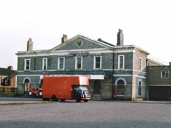
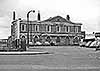
South Town station building looking south-west across the forecourt in May 1977 with the station clock and BR signage still present eight years after closure. The reason for the asymmetry of the building is the extension on the south end, left, added by the GER to provide extra accommodation for the stationmaster of the time's eleven-strong family. At least this extension matched the original building, unlike the brick monstrosity on the right which was the refreshment room added by BR in 1952. Just visible above the shuttering are two steel strips which once bore the metal letters spelling out 'Refreshments' in block capitals. Left of centre, the grassy strip marks one side of what had been a garden in the middle of the forecourt. Where the fencing can be seen at far left passed the tracks which led across the road to the goods yard. The houses, left, are the rear of Plevna Terrace, with Station Road being a little further south. The van hides the sign over what had been the station entrance; the sign stated 'Santa Fe Ltd', a company of American parentage involved in North Sea gas and oil exploration who rented the station building at this time. The van is a BMC FG; over the years these bore Austin or Morris badging, then BMC, then Leyland and as such were a mobile timeline for the decline of the British motor industry. BMC (British Motor Corporation) were the body formed in 1952 by the amalgamation of Austin, Morris (including Morris Commercial), MG, Riley and Wolseley. BMC later took control of Pressed Steel and Jaguar. Eventually becoming British Motor Holdings Ltd., they merged with the once-respected Leyland Motors to form British Leyland.
Photo
by Alan Young
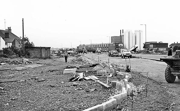
Yarmouth South Town station is no more in May 1984 as construction work for Pasteur Way, the A1243 link road to the A12, is underway. The camera is looking towards what was the south side of the station forecourt and where the person is walking towards the camera is where the tracks to the goods yard once ran. Left of centre lies a smashed lamp standard, perhaps that which stood casting light over what had once been the south side of the forecourt. The purpose of the windowless brick hut is not known. Lack of windows suggests that it may have been a store. The course of the new road slightly confuses things when attempting to visualise the railway; the tracks actually ran parallel with front of the hut and to the rear of the houses on the left. The new road became a continuation of Bridge Road, thus the camera is looking west-south-west over what had been the south side of the forecourt rather than directly at the station building.
Photo by John Mann 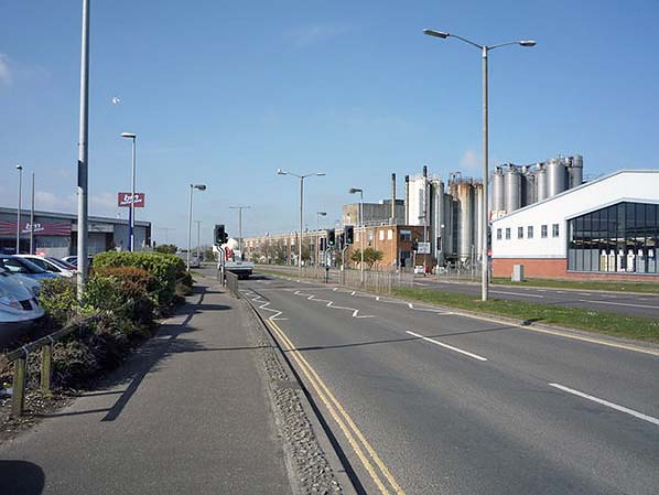
The view south-west along Pasteur Road in May 2016. The photographer was standing at what would have approximately been the bufferstop end of South Town station's platforms, in other words with the station concourse behind the camera. The former maltings would have stood just off the picture to the right and its railway dock where the modern pitched roof building now stands. The modern industrial plant is Pasta Foods Ltd. To get a location comparison from the maps, the factory stands opposite the south ends of Coronation Road and Coronation Green. Pasteur Road is the A1243 link road to the A12. The junction, which is a traffic island, is close to the site of Yarmouth South Town Junction where the Lowestoft line diverged. Beyond the A1243/A12 junction there is, as of 2017, there is a short section of trackbed of the former Beccles line extant although it is now difficult to discern as such. Beyond this, Gapton Hall Road now occupies a short length of the Beccles line trackbed, beyond which is residential development as far as Mill Lane. Thereafter, playing fields and allotments have swallowed up further trackbed as far as the junction of Lord's Lane and Cley Road. There is then more residential development alongside Doles Lane, after which the trackbed can be discerned to the outskirts of Belton. Of the Lowestoft line, the A12 now follows its course to a point near Victoria Road, Gorleston. Northwards from the A1243/A12 junction, the A12 now follows the course of the former railway over Breydon Viaduct, a new bridge having replaced the former railway structure, as far as the junction with the A47 and A149 close to Vauxhall station.
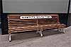
Photo by J Thomas, reproduced from Geograph under creative commons licence 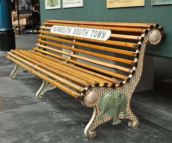 The GER bench from South Town station as preserved at the National Railway Museum and showing its ornate end with representations of a fishing net, shells and flat fish; both ends were so-treated. How many of these benches were produced is not known but there were at least two (see picture of two in situ at South Town). Who produced them is unknown and GER records are silent on the matter, which might suggest that they were produced at Stratford. The nameplate is not original to the bench. Whatever and wherever, these benches were certainly befitting of Great Yarmouth. Novelty designs such as this were by no means unique to the GER; the North Eastern Railway, for example, had a rather uninviting serpent design whilst the Furness Railway had a delightful design depicting red squirrels and grape vines, many of which survive still doing the job for which they were designed.
Photo by Phil Parker from his Flickr photostream
Click on thumbnail to enlarge
 Home Page Home Page
|
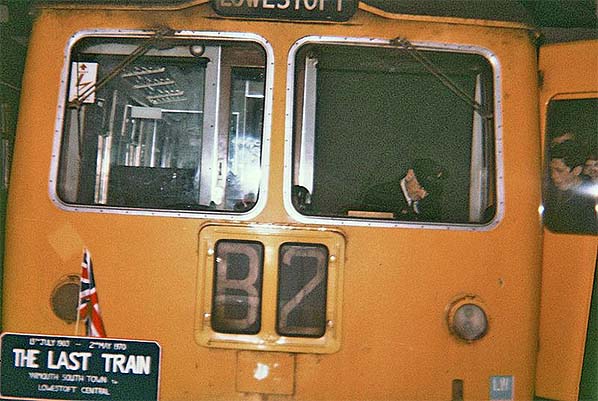 The last train from Yarmouth South Town awaits departure on Saturday 2 May 1970 as the driver signs autographs, a common occurrence when a line closed. At 21:10 the 6-car Cravens DMU rasped away towards Lowestoft and that was the end of Yarmouth South Town. Note the open cab door is painted yellow. This was one of several variations of the Rail Blue and yellow livery and this version did not sit well on DMU's at all, giving an illusion of them being short and dumpy A Cravens unit with yellow cab doors had been in action for much of the last day of the Yarmouth - Lowestoft line but it may or may not have been the same unit as seen here. The 'LW' at the bottom corner signified 'Lightweight', referring to the units' construction, and it was largely for this reason the Cravens units gained a reputation for rattling and vibrating. The headcode 'B2' was a familiar sight and many DMUs, when so-fitted, seemed to carry this display permanently. B2 meant simply a branch or local stopping service which, of course, many DMUs spent most of their time on. The headboard was an adornment often seen on last days or last trains and made with varying degrees of crudeness but that seen here looks to have been reasonably well made. It is mounted on a lamp bracket. The Union Flag was another common adornment but quite what its relevance was to a railway closure is hard to understand.
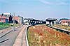

.JPG)