
Station Name: GOSWICK[Source: Alan Young]
old1.jpg) Goswick station, looking north-west from the down platform in 1958. This was the year when the station closed to passengers and it is not known whether this view shows it just before or just after closure. The brick structures in the foreground are the gents’ toilet and, beyond it – with the pitched roof – the building containing the booking office and waiting room. Beyond the level crossing the up platform has a timber building in which there was a waiting room and possibly a store. The 1901-built signal box is on the right. The chimneystacks and roof of the station house are visible beyond the down platform buildings (left) and in the background is one of the railway cottages. The goods siding was placed between the station house and the down main line, and there appears to be a wagon standing on it. The station remained oil-lit until it closed, and several of the NER-pattern lanterns are on the platforms and at the crossing.
Copyreight photo from Stations UK 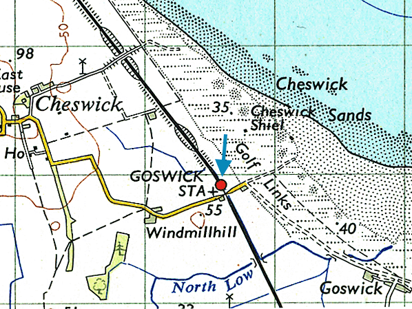 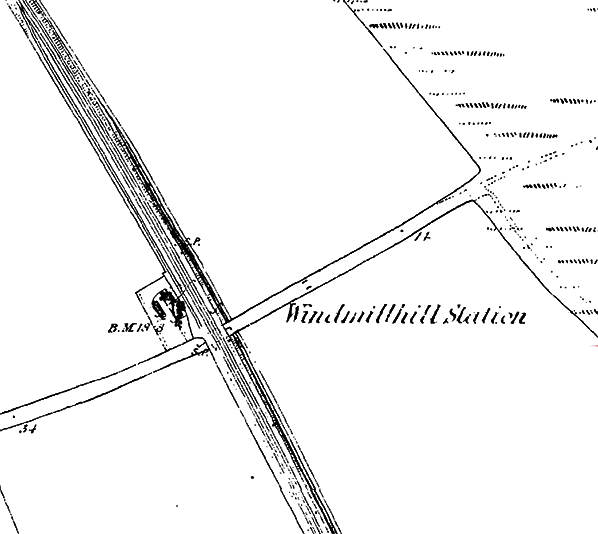
1866 1: 2,500 OS map. Until 1898 Goswick station was known by the North Eastern Railway as Wind Mill Hill. The Ordnance Survey version was ‘Windmillhill’. The station has not been seen in a public timetable before November 1870, but four years earlier it is marked and named on this map. It was possibly used, unadvertised, by market day trains before it officially became a public station. The station house (originally used by the crossing keeper) is shown south-west of the double-track main line, but a long siding runs from the down line north-west of the station and ends in front of the house. No platforms are shown on this map, but the position of the siding would prevent the down platform from being installed north-west of the crossing – thus it was built on the other side of the crossing while the up platform was located opposite the station house, north-west of the crossing
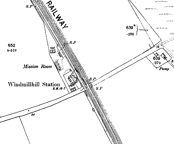
1898 1: 2,500 OS map. This was the year when the station’s name would change from Windmillhill [sic] to Goswick, taking its new name from the links golf course which opened in 1890 and whose club house is shown about 200yd east of the station; the golf course took its name from a hamlet about a mile south-east of the station. The platforms are shown at the station, and their arrangement is ‘staggered’ with the down (northbound) south-east of the level crossing and the up one to the north-west. The platform buildings are also shown though the up platform building is indistinct. The siding between the station building and the down main line is still shown and a goods platform can be seen, approached by a roadway which also gives access to two semidetached cottages and a Mission Room – surely with little prospect of a large congregation in such an isolated spot.
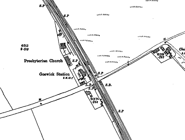 1924 1: 2,500 map. The principal changes to railway features since the 1898 map are the station name – now Goswick – and the addition of a signal box (in 1901) on the up side, south-east of the level crossing. The platforms and buildings are represented with greater clarity than on the earlier map. The goods siding is still in place in front of the station house. The Mission Room is now shown to be a Presbyterian church. A house has been built across the road from the station.
15.jpg)
Goswick signal box, looking north from a down train on 12 August 1969. This box was built in 1901 on the up side of the tracks, replacing an earlier one which was probably on the down side. The box seen here is an N2 design brick box but with an N4 roof. The up platform stood beyond the level crossing, but appears to have been demolished.
Photo by Alan Brown 2.jpg)
Goswick station looking north-west from a down train on 5 September 1972. In the foreground are the remains of the down platform, retaining its back wall, a lamp post and cradle and a wall of the former office building. Beyond the level crossing is the station building with its pitched slate roof and chimneystacks.
Photo by Alan Young 1.jpg) Goswick signal box, looking east over the level crossing c1970s. The box would close in 1982.
Photo by John Hinson from The Signal Box web site 3.jpg)
The station building at Goswick looking north-west from the level crossing in August 1981. It was constructed by the Newcastle & Berwick Railway in 1847. Its design closely resembled the building at Smeafield , six miles south, which also began its life as a gate keeper’s cottage before a passenger station was added and the building became the stationmaster’s house. Although it is much smaller and lacking the flamboyance of the buildings at the original N&B stations it shares with them the sandstone construction, the raised gables and kneelers at the edge of the gables. As built the structure will also have been given decorative ball finials on the gable crests and the ground floor canted bay would definitely not have had the ‘picture windows’ seen on this photograph. A goods siding used to extend in front of the station building and it served the ramped platform, seen far right. Brick-built semidetached cottages, constructed in NER days, are seen beyond the station building.
Photo
by Alan Young
4.jpg)
The remains of the down platform at Goswick station, looking south from the level crossing in August 1981. The platform face and much of the back-fill have been removed, but the back wall and four lamp posts, still with lantern cradles, survive. A platelayers’ hut is beyond the end of the former platform. In the distance are the Kyloe Hills/
Photo by Alan Young 9.jpg)
Looking south from the level crossing at the remains of Goswick station’s down platform in July 2015 The red brickwork is the back of the booking office building and the cream-coloured brickwork beyond, largely obscured by vegetation, is the back wall of the platform.
Photo by Terry Callaghan 14.jpg) The electrified East Coast main line, looking north-west from Goswick level crossing in July 2015. The up platform of Goswick station was formerly to the right of the tracks, where the warning sign is now placed. The station building can be seen on the far left
Photo by Terry Callaghan 13.jpg)
The station building at Goswick looking north-west from the level crossing in July 2015. It was constructed by the Newcastle & Berwick Railway in 1847. Its design closely resembled the building at Smeafield , six miles south, which also began its life as a gate keeper’s cottage before a passenger station was added and the building became the stationmaster’s house. Although it is much smaller and lacking the flamboyance of the buildings at the original N&B stations it shares some of their architectural features. A goods siding used to extend in front of the station building. Two railway cottages (far right) are partially obscured by vegetation.
Photo
by Terry Callaghan
11.jpg)
The former goods yard platform loading bank , seen in July 2015, is still well preserved at Goswick. It stands a few yards north-west of the old station house.
Photo
by Terry Callaghan
|
 Wind Mill Hill was an isolated farm standing a short distance from the extensive coastal sand dunes, and it is remarkable that the North Eastern Railway considered it worth providing a station in such a sparsely populated rural area, with no obvious source of traffic to the east of the station. It is unlikely that the company expected to attract tourist traffic to this isolated stretch of coastline. About a mile south-east of the station was the hamlet of Goswick, but no direct track or road connected the tiny settlement and the station. However the station gained a potential source of passengers when In 1890 Berwick-upon-Tweed Golf Club established a links course on the dunes and built its club house about 100yd east of Wind Mill Hill station. On 1 January 1898 the station was renamed Goswick, the name which had been chosen for the golf course.
 The gatekeeper’s cottage was north-west of the level crossing, on the down side of the railway, but when platforms were provided the down platform was placed on the opposite side of the crossing while the up platform was staggered, facing the cottage. Early OS maps show that a siding was installed between the main line railway and the cottage, preventing the building of a down platform in front of the cottage as had been done at Smeafield station.
 Goswick was one of the stations on the ECML in northern Northumberland which closed to passengers on 5 May 1941; elsewhere in Great Britain closures during World War II were uncommon. However on 7 October 1946 the station reopened, but Sunday services were not restored.
  The summer 1950 timetable was sparse, but the Thursday-only southbound call by a semi-fast train was a new introduction (no earlier than 1949). This might have been related to activities at Berwick Golf Club – adjacent to Goswick station, as noted earlier – and passengers who had arrived from Berwick on this train could return (on any weekday) in the early evening. The timetable would allow the few residents within the catchment area of Goswick station to visit Berwick market on a Saturday morning or spend a couple of hours shopping in Newcastle on Thursday or Saturday.
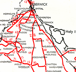 Goswick was one of ten stations between Newcastle and Berwick to close to passengers on 15 September 1958. The North Eastern Region timetable, which for several years had meticulously noted closures when they occurred and provided information on bus services that could be used instead, ended this practice with the winter 1958-59 timetable and made no reference to the many newly closed stations. Some of them remained, in error, on the regional map, but Goswick station’s name was removed and the circle representing it was almost erased. Because of this regrettable change in policy it is not known if any buses were available for the stranded Goswick residents. United (a bus company ‘associated’ with British Railways) shows no services to Goswick on the accompanying map.
 thumb5.jpg)
thumb6.jpg)
thumb7.jpg)
thumb8.jpg)
thumb10.jpg)
thumb12.jpg)

 Home Page