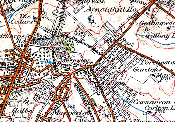
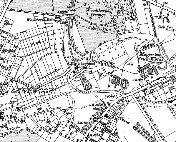
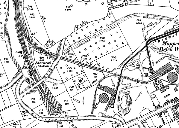
Notes: Sherwood station was, like St. Ann's Well, located in a cutting between two tunnels. To the south was Sherwood Tunnel (442yd) and to the north of the station was Ashwell's Tunnel (70yd), the shortest of the four tunnels on the line.
Sherwood was the only station on the suburban railway to be built on a curve. Access to the station was via an approach off Sherwood Vale into the station forecourt from where there was access to the goods yard. This included a cart weighbridge and office, lamp room, dock and cattle pen. The station had two facing platforms with ran under Sherwood Vale bridge at their south end. The main single-storey station building comprising a booking office and waiting room was located on the down platform with a brick waiting room on the up. As with other stations on the line, the buildings were designed by Thomas Chambers Hine. Both platforms were sheltered by wooden canopies with decorative valances supported by ornamental brackets. A wrought iron lattice girder bridge supported on cast iron columns connected the two platforms.
A 30-lever signal box was located beyond the north end of the down platform; this controlled all movements around the station. There were sidings on both sides of the line to the north of the station. There were two parallel loops on the down side, from these there was a short siding running in front of the signal box into a cattle dock behind the north end of the platform. There was no goods shed at Sherwood as the yard was not as busy as the other two stations. On the up side there were two exchange sidings where LNER rails met 'end-on' here with those of the Nottingham Patent Brick Company with a steel rope-hauled incline up to the brickworks; this was powered by a stationary engine at the top. Ascending and descending trucks were controlled from a small brick built hut to the east of the bridge at the bottom of the incline.
The two-storey stationmaster's house was between the forecourt and Sherwood Vale bridge behind the south end of the down platform. It was built from NPBC bricks with a slate roof. Its floor plan was a mirror image of the houses at St. Ann's Well and Thorneywood which were both built on the up side.
This station was the first on the line to be affected by the arrival of the electric tramcar, which reached Sherwood as early as January 1901. It was closed with the other intermediate stations on 1 July 1916.
The station was reopened for one day only on 10 July 1928, along with Thorneywood, when it was used to transport schoolchildren to and from Woodthorpe Park where they were to be inspected by King George V and Queen Mary as part of their visit to Nottingham.
 From 1931 onwards, the station was used for the thrice weekly freight service which operated between Daybrook and Thorneywood. The quantity of freight traffic was still considered acceptable; in 1935 the station received 1,197 loaded wagons and forwarded 195 loaded wagons. The up platform waiting room was demolished after the line was singled in 1930 and the footbridge was removed. After closure, further demolition gradually took place. In June 1953 the signal box was burnt down. The platforms and the remaining station buildings were demolished in 1965 prior to building two tower blocks of flats (now sheltered housing), called Winchester Court and Woodthorpe Court; the rows of garages built for the flats followed the curve of the platforms. The last building to go was the stationmaster's house which was demolished c late 1960s. From 1931 onwards, the station was used for the thrice weekly freight service which operated between Daybrook and Thorneywood. The quantity of freight traffic was still considered acceptable; in 1935 the station received 1,197 loaded wagons and forwarded 195 loaded wagons. The up platform waiting room was demolished after the line was singled in 1930 and the footbridge was removed. After closure, further demolition gradually took place. In June 1953 the signal box was burnt down. The platforms and the remaining station buildings were demolished in 1965 prior to building two tower blocks of flats (now sheltered housing), called Winchester Court and Woodthorpe Court; the rows of garages built for the flats followed the curve of the platforms. The last building to go was the stationmaster's house which was demolished c late 1960s.
In 1985 Briarwood Court was built immediately south of Sherwood Vale bridge, which is extant. The property is surrounded by high metal railings which make access to the cutting to the south of the bridge difficult. The cutting has been partially filled but it is possible to walk the full length of it, although there is no trace of the buried north portal of Sherwood Tunnel. At the south end of the station site more garages have been built in the cutting leading to the south portal of Ashwell's Tunnel, of which there is no trace. The bridge at the bottom of the incline to Mapperley brickworks is extant but the arch is blocked with metal railings.
Click here to read Ard Dunby's recollections of Sherwod station.
BRIEF HISTORY OF THE NOTTINGHAM SUBURBAN RAILWAY
In the 1880s, the city of Nottingham had expanded into its surrounding villages and hamlets which, in turn, had grown into suburbs. These needed to be connected to the rail network. At this time the only competition to the railways came from horse-drawn trams and omnibuses which were slow, could only carry light loads and not travel long distances.
The 1860s and 1870s had seen the unrivalled success of the London underground railway system and its associated commuter lines so, in the late 1880s, a group of Nottingham businessmen felt that the creation of a railway on similar principles would benefit the city’s rapidly growing suburbs.
Historical development
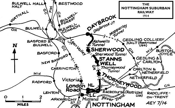
The Great Northern Railway had opened its Derbyshire extension line into Nottingham in 1878; however its principal concern had been to link up the numerous coal mines to passenger traffic. In addition, trains had to make a 7¼-mile circuitous journey from Nottingham, first travelling eastwards to Colwick (later known as Netherfield & Colwick) before heading north-west through Gedling, Mapperley and Daybrook to Basford which, on a direct route, was a mere 3¼ miles from the city centre. The Nottingham Suburban Railway, so its backers thought, could complement the Great Northern’s extension line as well as providing a more direct route into the city. An agreement was arrived at whereby the GN would work the proposed line, providing all the locomotives, rolling stock and staff; in return it would retain 55% of the gross receipts. Despite this arrangement, it is worthy of note that the Nottingham Suburban Railway company remained an independent entity until 1 January 1923 when it was absorbed by the London & North Eastern Railway.
Passengers were not the only motivation for building the line. One of the leading promoters, Robert Mellors, was chairman of the Nottingham Patent Brickwork Company whose works were on the proposed route at Thorneywood, and it was put forward that a branch be built to serve them. This plan received approval from a director of the company, Edward Parry, who would go on to become the line’s chief surveyor and structural engineer. The branch would become the only one of note from the line, running a distance of just 198yd, of which 110 were in a tunnel taking it beneath Thorneywood Lane before climbing an inclined plane along which wagons were hauled to and from the brickworks.
The company obtained its Acts during 1886 and these were strongly supported by Nottingham City Council. By October 1886 Parry had surveyed and staked out the route. Construction work began in June 1888. Some 3¾-mile in length, it ran from a junction with the Great Northern Railway at Trent Lane and headed north to another junction with the GN’s Derbyshire extension line at Daybrook. Intermediate stations were built at Thorneywood, St Ann’s Well and Sherwood.
Because of the hilly terrain, the railway proved extremely costly to build, with one-sixth of it built in four tunnels, the longest being just over quarter of a mile long. In addition, there were seven brick-arched bridges, nine girder bridges of which three were over 100ft in span, eight culverts and numerous retaining walls, embankments and cuttings. Construction costs were increased by a third as the Midland Railway insisted that all bridges carrying the line over its metals were at least 50ft wide whilst the Great Northern demanded a flyover at Trent Lane to avoid conflicts on their Nottingham-Grantham line.
Despite these adversities, the line was completed by 23 November 1889 and opened both to passenger and goods traffic on 2 December of that year.
Operational history, decline and closure
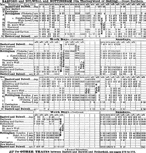
In 1890 there were ten trains per day running out of London Road along the line to Daybrook, four of which continued through to Newstead. In the opposite direction were nine trains of which four originated from Newstead. There was no Sunday service. The journey time from Nottingham to Daybrook was a very respectable 13 minutes. By 1895 there was a through train to Ilkeston which, on Fridays, was extended to Derby Friargate.
Unfortunately, within a little more than ten years, two developments occurred that would render the Nottingham Suburban Railway superfluous. The first was the arrival of the Great Central Railway which, in 1900, had opened up an even more direct route into Nottingham. Trains along the GC’s own Leen Valley railway could run directly from Newstead via Bulwell, New Basford and Carrington into Victoria Station, thus cutting out the lengthy negotiations of Daybrook Junction and Leen Valley Junction on the Great Northern route.
The second was the introduction of the electric tram. Horse-drawn trams had been operating in Nottingham since September 1878; however the arrival of the electric tram offered a quicker, more frequent service than the trains. The first route opened to Sherwood - running along Mansfield Road close to Sherwood Station - on 1 January 1901. Extensions to St Ann’s came on 21 February 1902, Thorneywood on 16 December 1910 and Daybrook on 1 January 1915. With their comparatively light loads and easy acceleration, the trams could negotiate the gradients in the hilly east of Nottingham more easily than steam locomotives. Indeed the clanging of the tram bell would, in the coming years, often sound the death-knell for many a suburban railway station.
A third factor was offered to Railway Magazine (August 1961) by a correspondent, J P Wilson, as an addendum to an article about the Nottingham Suburban Railway in the magazine two months earlier. He noted that the line traversed one of the few areas of the city of Nottingham where little housing development had taken place by the start of World War I. Only Thorneywood station was at all conveniently situated when the line was open, while St Ann’s Well was particularly remote. He added: ‘In the last thirty years small housing estates have come near to all three stations, far too late in the day to have any influence. One can only conclude that the whole project was something of a gamble, especially as to passenger traffic’.
The 1 in 49 gradient from Trent Lane Junction, which was also on a curve, posed particular problems for the GN’s Stirling 0-4-4 tanks which worked the line. In order to achieve faster journey times than the trams, some of the suburban services were run non-stop from London Road to Daybrook. By 1914, whilst there were still eight trains per day each way along the line, only four of these stopped at the intermediate stations. For example, St Ann’s Well saw departures for Basford & Bulwell at 7.55am and, to Shirebrook, at 9.11am, 1.20pm and 4.58pm. In the opposite direction, trains departed for Nottingham at 8.24am, 2.21pm and 6.01pm. It is also worthy of note that other trains passed through the station at 11.38am, 8.40pm and 9.50pm en route to Shirebrook and to Nottingham at 10.36am, 12.59pm, 9.20pm and 10.41pm. Even before the closure of the intermediate stations - which at this time was less than two years away - more passenger trains passed through than stopped. One can only imagine the long-deserted platforms at St Ann’s Well which, just a few years earlier, had anticipated unprecedented numbers of customers.
As a supposed wartime economy measure, the three intermediate stations were closed to passenger traffic on 13 July 1916 and, thereafter, just two trains a day along the Leen Valley route used the line. After the war it became evident that the Great Northern had little interest in promoting services along the line nor reopening the intermediate stations. Bradshaw of July 1922 shows that, just prior to grouping, only three trains passed daily over the line.
On 25 January 1925 the collapse of Mapperley Tunnel on the Great Northern extension brought a brief flurry of activity for the Nottingham Suburban when all Leen Valley passenger and coal traffic was diverted over the line whilst repairs were effected.
Also, on 10 July 1928, their majesties King George V and Queen Mary opened the Royal Show at Wollaton Park and the new university buildings. Between these two events their majesties reviewed a huge gathering of school children in Woodthorpe Park. As the nearest station was Sherwood, both Thorneywood and Sherwood stations were renovated and re-staffed for the occasion. This made it possible for 6,550 of the 17,500 children and 284 of their teachers to be brought in on 13 special trains. It is ironic that, on that one day, the two stations saw more activity than they had ever done during their operational days.
The line was converted to single track with the removal of the down line on 9 February 1930 when the signal box at Sherwood was closed and all signalling removed. The line was then worked by staff who unlocked the ground frames controlling the siding connections. Not long after, the footbridges and canopies were removed from the stations, a clear indication that they would never reopen. The last passenger train to use the line was the 5.05pm Nottingham Victoria to Shirebrook via Trent Lane Junction on 14 September 1931. Services had lasted just 41 years, with the intermediate stations faring even worse with an operational life of just 26½ years.
The next misfortune to befall the line occurred on the night of 8 May 1941 when, during Nottingham’s worst air raid of the Second World War, considerable damage was done in the Sneinton area. A bomb landed on the southern section of the line damaging a bridge over the Midland Railway and blowing away part of the embankment. This was never repaired and buffer stops were erected at either side, effectively creating two dead ends.
Subsequently the goods service along the line was reduced to a thrice weekly pick-up, carrying domestic coal between Daybrook and Thorneywood only. But even this ended on 1 August 1951 thus bringing the story of the Nottingham Suburban Railway to an end. The last-ever passenger train to run over the line had been a chartered enthusiasts’ special between Daybrook and Thorneywood on 16 June 1951. Apart from a short section at Daybrook, the tracks were lifted between June and October 1954. When the connection at Daybrook Junction was removed on 24 February 1957, the end of the line had truly come.
Today little evidence remains of the Nottingham Suburban Railway. Being situated in the city’s suburbs, both residential and industrial developments have obliterated most traces of it. The line's course from Thorneywood station to Sneinton Tunnel has been made into a footpath. The latter’s portals have been partially obscured by infilling but access into the bore is still possible for members of the local gun club. Descending to Sneinton Dale, nothing remains of the three-arch viaduct which once took the line over it and the site is now occupied by a doctor’s surgery, medical centre and police station. The footpath resumes at a point just south of Sneinton and follows onwards to Colwick Road where the bridge has been removed. The girders of the bridge over the Midland Railway have gone; however the segmental arch and abutments at Trent Lane still exist.
Few people are now aware that the Nottingham Suburban Railway existed. The line which was built to serve early commuters has almost disappeared but one cannot help wonder whether it might have found a fruitful role today, when we are all being urged to ditch the car in favour of public transport. Could it have formed the basis of a regenerated public transport infrastructure in the city? We will never know.
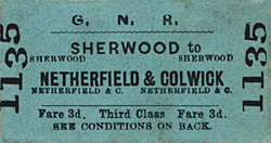
Ticket from Michael Stewart. Bradshaw from Nick Catford. Route map drawn by Alan Young.
Further reading:
Story of the Nottingham Suburban Railway: Pt. 1: Conception, Construction, Commencement David G Birch - Book Law Publications 2010
The Story of the Nottingham Suburban Railway: v. 2: The Operational Years David G Birch - Book Law Publications 2012. Volume 3 has yet to be published.
To see other stations on the Nottingham Suburban Railway click
on the station name:
Nottingham Victoria, Nottingham London Road Low Level, Nottingham London Road High Level, Thorneywood, St. Ann's Well & Daybrook
Take the Grand Tour - A photographic survey of all the tunnel portals and bridges along the Nottingham Suburban Railway in 1904. |

old7.jpg)
old8.jpg)
old1.jpg)
old2.jpg)
old11.jpg)
old12.jpg)
old3.jpg)
old12.jpg)

 Home Page