|
Notes: The gap in the cliffs, plus its proximity to the continent, has meant that the site of Dover has been used for shipping long before the Romans arrived probably dating back to the Bronze Age. The first artificial harbour was constructed from a natural pool on the west side of the bay by 1495. On 10 June 1606 a new organisation, the Dover Harbour Commissioners, under the chairmanship of the Lord Warden, came into being to administer the harbour. By that date it was already being used by small, fast sailing craft carrying mails to Calais and Ostend - the first Channel 'packets'. By the mid eighteenth century, three dock basins had been constructed. By the end of the Elizabethan era the harbour comprised the Little Paradise, Great Paradise and the Pent. As a result of the Passing Tolls Act to 1718 the Crosswall we see today was built. This divided the Great Paradise called, at that time the Bason. Later, after massive works were carried out it became the Granville Dock.
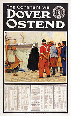
On 15 June 1820 the first paddle steam packet Rob Roy took on the Dover-Calais crossing. Paddle steamers were soon replaced the sailing packets, services were initially provided by the Admiralty but 1821the service was passed to the Post Office who held the contract till 1837. The South Eastern Railway opened its line between Folkestone and Dover on 7 February 1844, and it formed a subsidiary company to start operating steamer services from Folkestone Harbour to Calais and Boulogne.
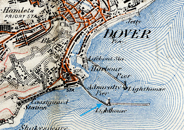
 At the beginning of the nineteenth century, it was proposed that a haven of refuge for the fleet should be constructed in Dover Bay. The foundation stone of the Admiralty Pier was laid on 2 April 1848, as the first stage in the proposed harbour of refuge for the Royal Navy, Admiralty Pier was to form the western arm. The material used was tooled granite ashlar but later pre-cast concrete blocks were used beneath the water. The Admiralty Pier was the first marine structure in the country in which pre-cast concrete blocks were used. It was designed by the distinguished marine engineer James Walker and his pupil partner Alfred Burges, and was completed after his death by Sir John Robinson McClean FRS. Sir John Hawkshaw, Engineer to the Harbour Commissioners, also had a design input. The main building contractor was Henry Lee & Sons. It was envisaged as the western arm of this proposed haven. By 1850 the pier effectively stopped the silting of the harbour mouth, as it cut off the easterly drift of shingle from the Folkestone direction. By early October 1850 the foundation of the pier was 650ft in length but on 8 October an intense storm, centred on Dover, destroyed all the works that had been undertaken. Piles, 18in square, were snapped and three huge diving bells were carried away to sea – two were later found. At daybreak the bay was strewn with fragments of timber and machinery including broken cranes, air-pumps and traversers. The Duke of Wellington rode from Walmer to inspect the damage, accompanied by civil engineer James Walker. Along with Colonel Blanchard of the Ordnance, Wellington went to the extreme end of what remained of the pier looking carefully at what had survived. At the beginning of the nineteenth century, it was proposed that a haven of refuge for the fleet should be constructed in Dover Bay. The foundation stone of the Admiralty Pier was laid on 2 April 1848, as the first stage in the proposed harbour of refuge for the Royal Navy, Admiralty Pier was to form the western arm. The material used was tooled granite ashlar but later pre-cast concrete blocks were used beneath the water. The Admiralty Pier was the first marine structure in the country in which pre-cast concrete blocks were used. It was designed by the distinguished marine engineer James Walker and his pupil partner Alfred Burges, and was completed after his death by Sir John Robinson McClean FRS. Sir John Hawkshaw, Engineer to the Harbour Commissioners, also had a design input. The main building contractor was Henry Lee & Sons. It was envisaged as the western arm of this proposed haven. By 1850 the pier effectively stopped the silting of the harbour mouth, as it cut off the easterly drift of shingle from the Folkestone direction. By early October 1850 the foundation of the pier was 650ft in length but on 8 October an intense storm, centred on Dover, destroyed all the works that had been undertaken. Piles, 18in square, were snapped and three huge diving bells were carried away to sea – two were later found. At daybreak the bay was strewn with fragments of timber and machinery including broken cranes, air-pumps and traversers. The Duke of Wellington rode from Walmer to inspect the damage, accompanied by civil engineer James Walker. Along with Colonel Blanchard of the Ordnance, Wellington went to the extreme end of what remained of the pier looking carefully at what had survived.
Work was restarted, but by 1853 national discontent had been roused over the cost of building a harbour of refuge at Dover. In general it was believed that Folkestone – Hythe Bay would be the better place to site a harbour of refuge. Further, it was being said that what remained of the proposed Admiralty Pier was putting the town of Dover in danger of being flooded. The critics added that this ‘might be no bad thing as the population is made up of land sharks.’ Agitation was such that on 27 August that year Sir James Graham, First Lord of the Admiralty, headed a retinue of delegates to Dover on an official fact-finding visit. Captain Luke Smithett, of Dover, brought them to the town on the Vivid mail packet.
The ship tied up on Admiralty Pier and the Mayor, Charles Lamb, and the two members of Parliament, Edward Rice and Henry Cadogan (later Viscount Chelsea) MP for Dover, met the influential officials. The Board members inspected Archcliffe Fort where the Royal Artillery had recently fixed large guns to protect the envisaged harbour of refuge. At the time Napoleon III of France, following an official visit to Calais and Boulogne, had suggested that one, if not both, of the ports should be expanded into harbours of refuge. The Board members report stated that work was progressing well and that the town and harbour was in danger but from forces in France. A subsequent Royal Commission recommended that the Admiralty Pier should be extended and that a gun turret should be incorporated.
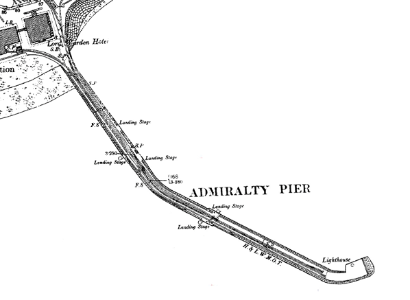
With the arrival of the South Eastern Railway the original plans for the pier were altered to provide a station that could take passengers and goods directly to the cross-channel ferries. The first section of pier was 800ft long and completed in 1854, and the second in 1864. On 1 September 1854 the Admiralty agreed that passenger trains would be allowed on to the Pier where there would be interchange with continental ferries, and in 1860 the southernmost line at Dover station was extended through the back of the trainshed curving round on to Admiralty Pier. By late 1861 the SER was running trains along it on a single track from the terminus.
During the construction of the Dover terminus the Cinque Ports pilot’s lookout station on the adjacent Cheeseman’s Head was demolished in 1844 and in 1848 it was replaced with a highly ornate tower, built of stone and standing on a bed of concrete 10ft thick. The new tower stood just to the south of the Dover station.
From the outset, SER had the lucrative government mail train and passage contract at Folkestone. When, in 1853, the Mail Packet Service from Dover was to be transferred from the Admiralty to private contractors they expected that they would get it. However, it went to Messrs Jenkins and Churchward and SER virtually turned its back on Dover.
In 1861 legislation did away with the Passing Tolls acts and created the reconstituted Dover Harbour Board. On 22 July 1861 the London, Chatham & Dover Railway opened its line from London through to Dover. On 1 November 1861 this was extended to a new station called Dover Harbour on Elizabeth Street, close to the SER terminus. Although adjacent to the harbour, LC&DR passengers had to walk along Admiralty Pier to reach the ferries.
The SER had always intended to concentrate its ferry services on Folkestone but eventually swallowed its pride and moved the Princess Clementine, an iron paddle steamer built by Laird Brothers and launched in 1846, together with the Princess Maud, built by Ditchburn and Mare and launched in 1844, from Folkestone to Dover. The ships plied between Dover and Ostend but the service was short-lived, ceasing in April 1862. Thereafter the SER concentrated most of its resources into developing Folkestone Harbour, which became its principal base for cross-Channel ferries.
Dover Harbour was not a terminus for long and the LC&DR petitioned Parliament to run their trains along Admiralty Pier. In the meantime, in 1863 they won the coveted Mail Packet contract for Dover! Although the two companies, with the blessing of Parliament, entered into the Continental Agreement because of the Mail contract, the two Chairmen of the railway companies, Sir Edward Watkin of SER and James Staats Forbes of LC&DR, were the most bitter of enemies. The Agreement allowed for all railway receipts appertaining to the Channel Passage ports between Margate and Hastings, to be pooled and then divided in agreed portions between the two companies.
In 1864, three years after the London, Dover and Chatham Railway had arrived in Dover, both railway companies were allowed to extend their services along the newly finished Admiralty Pier. As the new pilot's tower stood in the way of the SER line the ground floor, which had a ceiling height of 20ft, was gutted to allow trains to run through it onto the Admiralty Pier. The tower was eventually demolished in 1913 when a second track was required. Trains first ran onto the pier on 30 August 1864 with separate platforms provided for the two companies. There was only just room for a double line on the pier, and the two narrow platforms, one behind the other, were against the west wall of the of the pier below the promenade. The platform ran round the first bend in the pier terminating beyond the next landing stage. In rough weather waves broke over the pier and the transshipment of passengers and luggage became a nightmare.
Because of the rivalry neither company showed any real interest in the Agreement, much to the detriment of both companies’ profits. The SER continued to promote Folkestone as its principal base and built an attractive new Shorncliffe station (now Folkestone West) at Cheriton, which was outside of the Agreement area. LC&DR retaliated by opening a branch line from Sittingbourne to Queenborough on the Isle of Sheppey and from there provided steam packets to Flushing. The SER countered this by opening a new route via Port Victoria, on the opposite side of the River Medway estuary from Queenborough. Litigation ensued and, throughout, the Dover passage and train services suffered.
With the ferry services in operation the third phase of the pier’s construction was delayed by discussion as to how the pier should be completed. It was eventually decided to construct a fort at the south end armed two powerful Armstrong 16in, 81 ton rifled muzzle loading (RML) guns, the largest emplaced anywhere in the UK. The guns, originally steam-driven, were the only steam powered guns ever possessed by the coastal artillery in Britain. A contract was awarded for a further 1000ft; this was completed in 1871. The pier was now 2,100ft long and had cost £693,077 but the harbour of refuge was put on hold by the government at that time. The fort was not completed until 1880 and it was 1885 before the guns were first fired. The fort was known as the Admiralty Pier Gun Turret. It should be stressed that the pier was owned by the Admiralty and was principally a military fortification. The railway companies had to pay the Admiralty for the privilege of using the pier for their train and ferry services.
On 1 January 1877, there was a terrific storm at Dover that damaged the narrowest part Admiralty Pier – the centre curve of the parapet which was 5ft 6in wide. Shortly after it was replaced with a stone-faced 12ft parapet filled in with concrete which is in situ today. Dover builder, William Adcock, who had completed the later work on the Admiralty Pier, undertook the repair of the upper galleries.
John Bravington Jones describes the pier in his A Perambulation of the Town, Port and Fortress which was published by the Dover Express in 1907. ‘Mr Walker, C.E., was entrusted with the designing of the harbour, which was commenced in 1847. That work, started from a point then known as Cheeseman's Head, was intended to be the western arm of the great harbour; but, long before that section was finished, the Government had abandoned the complete scheme of enclosure, contenting themselves with carrying the pier out to an extent of 2100ft, which was finished in the year 1871. The total sum paid to the contractors for the work was £679,368, equal to £323 10s. per foot. Later, a fort was built at the end of the Pier, with a revolving turret, containing two 81-ton guns, that work costing an additional £150,000.
The Admiralty Pier, as this great work was - and is still - called, has been an enormous advantage to Dover, more especially because it provided landing stages for cross-Channel steamers. As speedily as possible the Admiralty Pier was made to answer that purpose, and it was first used on Saturday 14 June, 1851, when the Father Thames landed 50 passengers at the first landing stage. The first Channel steamer to use it was the Princess Alice, which landed 86 passengers on 19 June, 1851. Previous to that date, the steamers arriving at low water had to land their passengers in small boats; and seeing that, at that time, passengers landing and embarking at Dover numbered 3,715 per week it may be easily imagined what a comfort that Pier was regarded by Continental travellers; while, on the other hand, it must have deprived boatmen of a lucrative employment.’
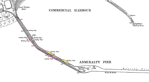
In 1891 the Dover Harbour Board wished to extend the pier-head at the seaward and give it a more rounded shape as the rip tide was eroding it. The Dover Harbour Board was established in 1606 by Royal Charter from King James 1. The eastern arm of the Harbour of Refuge was never begun and, to meet the demand of cross-Channel trade, plans were made to build a smaller commercial harbour. The eastern arm of this was the Prince of Wales Pier and construction did not begin until 1893.
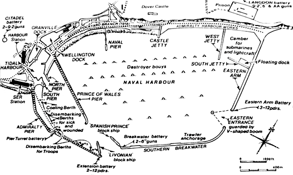
The construction of Admiralty Harbour was taken a step further in 1897 when construction commenced on the Eastern Arm (Prince of Wales Pier), the Southern Breakwater and a further extension to the Admiralty Pier commenced in 1898. The Admiralty Harbour was designed to provide a protected anchorage for the naval fleet and increase the protection of the existing commercial harbour. Admiralty Harbour was constructed by the firm of Coode, Son & Mathews, the successor firm to Sir John Coode, probably the greatest harbour engineer of the nineteenth century. The pier extension was constructed of concrete blocks of 26 to 42 tons each, faced above sea level with tooled granite ashlar. Work had already begun on Dover Harbour Board's commercial harbour scheme with the construction of Prince of Wales Pier, and the plans for this were therefore amended. The plans for the harbour included a 2,000ft extension of Admiralty Pier bring it to a final length of 4,140 feet, an Eastern Arm of 2,900ft and a breakwater of 4,200ft. This entirely enclosed the bay leaving an Admiralty harbour of 610 acres and a commercial harbour of 68 acres.
Despite problems with currents caused by the initial building of Prince of Wales Pier beyond the length of the incomplete Admiralty Pier, Dover flourished and in 1904 transatlantic liners began to use the port. This proved very short-lived with the Hamburg Amerika Line moving to Southampton in 1906, after a series of collisions in the harbour mouth, and the other liner companies followed suit over the next two years. The problems with the entrance were eased when the piers and breakwaters were finished but have never been resolved..
Continuous traffic growth in the later years of the nineteenth Century underlined the need for improving the Admiralty Pier which was open to the elements. The plans for Admiralty Pier were amended in 1906 to allow the building of a new station for the South Eastern & Chatham Railway on reclaimed land on the north side of the pier. This would replace the existing station on the Pier which was always susceptible to closure during heavy seas. In the meantime a second, wider platform was provided on the east side of the pier linking two landing stages between the first bend and the turret. The platform was built of timber at both ends but the central section was of concrete with a canopy for weather protection covering the platform on one side and the landing stages on the other side.
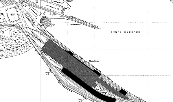
Dover Harbour, which is generally acknowledged to be one of the greatest feats of port construction at that time, was completed in 1909. The walls and piers were built of large blocks weighing from 30 to 40 tons. These blocks were made of concrete, with a granite facing to those that were to be placed on the outside surfaces of the walls above water level.The completed harbour was opened on 14 October 1909 by H.R.H. the Prince of Wales, the future King George V. In 1909 work started on a new station. It was completed in 1914 but with the start of WW1 the continental ferry service ceased to operate.
The pier and the new station were taken over for military use and the new station opened as Dover Admiralty Pier, for military traffic only, in February 1915 when it became the principal ambulance railway station. The original Admiralty Pier station had closed with the withdrawal of continental ferries in August 1914 after the start of WW1. The ferries were soon deployed as troop carriers to the Continent and as passenger ships for the return journey. Dover was a key location during WW1 as a major embarkation port for all three services with the pier coming under military control. The landing stages that had previously been used by the public travelling to and from France were now used for disembarking sick and wounded soldiers and a new landing stage was constructed on the pier extension for use by troops. Troops and equipment were sent from Dover Harbour to the trenches, and it was a haven for warships and submarines. The harbour operated the Dover Patrol, consisting of about forty warships, motor boats and fishing vessels which kept control of the English Channel.
With the restoration of continental services after the war the new station was renamed Dover Marine in 1918 and opened for passenger traffic on 18 January 1919. Much of the north end of Admiralty Pier was incorporated into the trackwork around the new Dover Marine station. In 1926 Admiralty Harbour was recognized to have limited military use and it was decided to hand it, including the Admiralty Pier, to the Dover Harbour Board for administration as a commercial undertaking.
Dover Harbour was particularly important in the Dunkirk evacuation when 200,000 men were returned from Dunkirk to Dover in eight days. All ordnance was removed from the pier in 1944 and the military store and accommodation buildings around the turret were demolished in 1958. More recently the Admiralty Pier, and part of the pier extension, has been widened in order to build two cruise terminals, terminal 1 in 1996 and terminal 2 in 2000..
The Admiralty Pier and associated structures including the Admiralty Pier lighthouse were Grade II listed by English Heritage on 16 December 2009. This listing excludes the turret which was designated a Scheduled Ancient Monument on 29 April 1975.
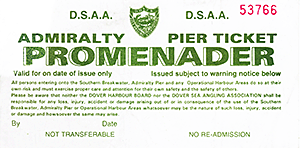 After a period of closure for refurbishment the pier promenade is accessible to the public as far as, but not including the turret. Access is controlled by the Dover Sea Angling Association on behalf of the Dover Harbour board. The toll booth is located at the south end of the elevated walkway to Dover Western Docks Station. Access to the pier for promenaders is £1 with fishermen paying £7 per rod. The pier is open are 08:00 – 21:00 daily except Friday and Saturday when the pier will remain open all night. After a period of closure for refurbishment the pier promenade is accessible to the public as far as, but not including the turret. Access is controlled by the Dover Sea Angling Association on behalf of the Dover Harbour board. The toll booth is located at the south end of the elevated walkway to Dover Western Docks Station. Access to the pier for promenaders is £1 with fishermen paying £7 per rod. The pier is open are 08:00 – 21:00 daily except Friday and Saturday when the pier will remain open all night.
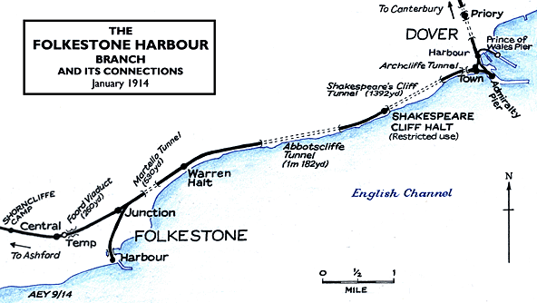
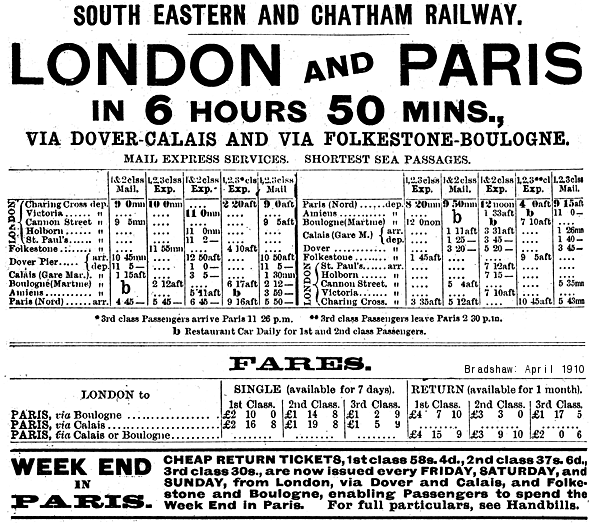
Route map drawn by Alan Young. Bradshaw from Nick Catford
For further information on Dover's railways and the Admiralty
Pier see Dover
- Lock and key of the Kingdom web site and East
Kent Local History Pages for pictures of railway remains
at Admiralty Pier.
Special thanks to the Dover Historian web site for help with this feature.
Click here to see a film of a train journey between Folkestone Junction and Dover Priory in the 1920s.
See special feature: Admiralty Pier Gun Turret
Sources:
|

pier_old27.jpg)
pier_old36.jpg)
pier_old26.jpg)
pier_old32.jpg)
pier_old40.jpg)
pier_old25.jpg)
pier_old36.jpg)
pier_old19.jpg)
 Home
Page
Home
Page
